At a time when the global population is rapidly approaching 8 billion people, agricultural researchers have an important role to play in meeting the challenges of increasing productivity to meet the high demand for food. This means advancing agricultural knowledge and developing innovative solutions to improve crop yields and resilience.
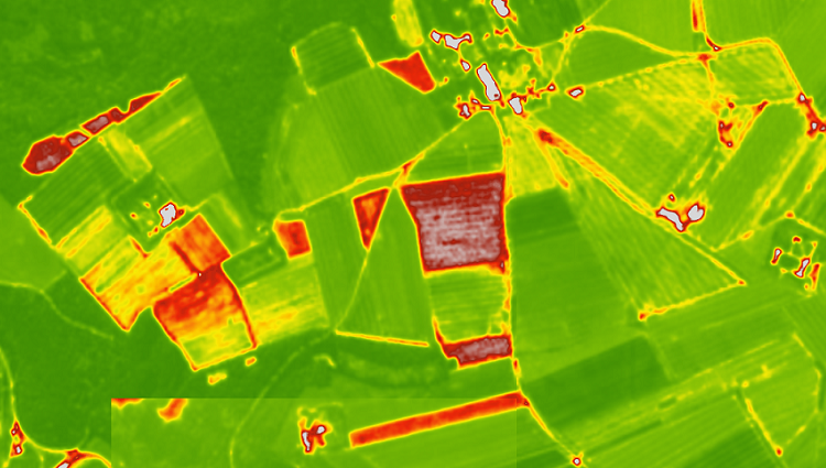
21st century tools such as smart farming software, high-precision GPS, sensor technologies, robots and drone-based agricultural analytics have revolutionised the way data is collected and tested. These technologies are enabling agribusinesses to conduct more trials over larger areas and gain deeper and more comprehensive insights into their high-value crops than ever before.
Many of these agricultural trials start with stand counts at the beginning of the season. A simple but important measure of how many plants are emerging, stand evaluations have evolved over the years. These methods can produce stand estimates of varying degrees of accuracy, although some still rely on manual methods such as hula hoops. Nowadays, we have highly accurate AI-powered stand counts that can be performed in a fraction of the time compared to traditional methods.
But stand counts are just the starting point. Once you have this data, you can use drone-based analytics to gain deeper insights into your land and make more informed decisions. But what should you analyse next? The answer to this question depends on your stand count results. If you have good plant emergence, what should be the next step? But what if your stand count results show poor plant emergence? Are there other aspects you should take into account?
In this article, we will examine the question “I have stand count results; what should I do now?”.
Here’s What You Should Do to Address Poor Plant Emergence
If stand count results indicate poor plant emergence, it is important to investigate the underlying causes and take appropriate action. Drone-based agronomic analytics offer valuable insights to diagnose problems and guide future crop development:
High Resolution Imaging:
Drones equipped with advanced cameras can capture detailed images of the entire land area. Analysing these images helps identify gaps or inconsistencies in output, illuminating potential problems such as disease, planting depth differences or pest damage. Based on this valuable information, researchers can design targeted experiments or interventions to address these challenges.
Multi-Spectral Analysis:
Using drones equipped with advanced sensors helps researchers to assess plant health and vigour. By analysing the spectral reflectance of plants, researchers can detect invisible signs of stress, nutrient deficiencies or disease symptoms. This data helps to understand how these factors affect output and makes it easier to explore appropriate management strategies or future experiments.
Environmental Monitoring:
Using drone-based analytics can reveal important environmental data for understanding output factors. Thermal sensors can assess soil moisture levels and identify zones of insufficient moisture, helping to detect irrigation or drainage problems. Temperature mapping can also illuminate how localised microclimate variations influence emergence rates.
Next Steps Following Good Plant Emergence
If the stand count results indicate a good output, you can turn your focus to optimising product performance and conducting comprehensive trial evaluations. In these scenarios, consider the following drone-based analytics:
Crop Health Monitoring:
Drones equipped with sensors such as NDVI or multispectral sensors offer researchers the ability to monitor crop health throughout the season. Early detection of stress or disease allows researchers to gather valuable information and take precautions in advance.
Integrating drone imagery with other data, such as geographical weather, soil conditions or planting techniques, gives researchers a holistic understanding of seed, treatment or input performance and enables informed decisions on crop market position or marketing strategies.
Trap Analysis:
Drones equipped with high-resolution RGB sensors can capture detailed images of vegetation. Researchers can analyse parameters from two-dimensional vegetation coverage, three-dimensional plant height and plant health monitoring flights to spectral information. These metrics offer insights into the homogeneity and density of the plant stand and facilitate observations on seed quality, treatment efficacy, planting practices or overall crop performance.
Phenotyping and Yield Estimation:
Drone-based phenotyping offers researchers the ability to collect high-resolution data on various plant traits, including plant height, canopy area or flower cover. This data allows researchers and crop developers to quantify plant growth dynamics, evaluate yield predictors and assess how it responds to different treatments. Drone-based phenotyping, combined with other field observations, provides a comprehensive understanding of how the plant develops in different environments and how this development affects yield.
Stand count results are often not homogenous across the whole of a trial and a section or individual part of your research site will fall into both the ‘poor emergence’ and ‘good emergence’ categories of your study. Therefore, depending on your research objectives, your trial’s analytical programme may include some or all of the above.
In conclusion, drone-based agricultural analytics is a powerful tool to enhance your agricultural research. Using the various drone-based analytics available through user-friendly platforms such as FieldAgent enables you to develop a comprehensive understanding of your land and helps you make faster and more informed decisions to determine the direction of your research or crop development programme.
Contact Us!
Feel free to contact us to learn more about the latest developments in agricultural technologies and to get detailed information about the products and services offered by Agrovech. You can visit our website at www.agrovech.com or use the contact details below to contact us directly:
Email: [email protected]
Address: Sakarya Teknokent Esentepe Mahallesi Akademiyolu Sokak Technology Development Zones
Building:2 – ROSEM No:21
As Agrovech, we continue to offer smarter, more sustainable and more efficient solutions in the agricultural industry. We are happy to help you and contribute to the agriculture of the future. Contact us so that we can offer customised solutions for your needs and let’s shape the future of agriculture together!
